


Top 10 Longest Bridges in India
1. Dhola-Sadiya Bridge: 9.15 km, Tinsukia, Assam
2. Dibang River Bridge: 6.2 km, Arunachal Pradesh
3. Mahatma Gandhi Setu: 5.75 km, Patna, Bihar
4. Bandra Worli Sea Link: 5.6 km, Mumbai, Maharashtra
5.Bogibeel Bridge: 4.94 km, Assam
6. Vikramshila Setu: 4.70 km, Bhagalpur, Bihar
7. Vembanad Rail Bridge: 4.62 km, Kochi, Kerela
8.Digha Sonpur Bridge: 4.55 km, Patna, Bihar
9. Arrah Chhapra Bridge: 4.35 km, Saran, Bihar
10. Godavari Bridge: 4.13 km, Rajahmundry, Andhra Pradesh
Dhola-Sadiya Bridge –
The Dhola-Sadiya Bridge, also known as the Bhupen Hazarika Setu, is a significant Infrastructure project in India. It is located in the Northeastern State of Assam and spans the Brahmaputra River, connecting the town of Dhola in Assam to Sadiya in the state of Arunachal Pradesh.
Here are some key points about the Dhola-Sadiya Bridge:
Length: The Bridge is Approximately 9.15 kilometers (5.69 miles) long, making it one of the longest Bridges in India.
Inauguration: The Dhola-Sadiya Bridge was Inaugurated on May 26, 2017, by Prime Minister Narendra Modi. It was opened to the public to improve connectivity in the region.
Strategic Importance: This Bridge has strategic significance as it provides year-round connectivity to the Northeastern State of Arunachal Pradesh. Before its construction, the region was often cut off from the rest of the Country during the Monsoon Season when the Brahmaputra River swelled and made ferry services unreliable.
Boost to Economic Development: The Bridge has significantly boosted Economic Development and trade in the region. It has reduced travel time and Transportation costs for people and goods moving between Assam and Arunachal Pradesh.
Named after Bhupen Hazarika: In 2018, the Indian Government renamed the bridge as the “Bhupen Hazarika Setu” in honor of Dr. Bhupen Hazarika, a renowned Assamese singer, Composer, and Cultural Icon.
Construction: The Construction of the Dhola-Sadiya Bridge was a challenging Engineering project due to the Large span across the Brahmaputra River and the region’s difficult terrain.
Overall, the Dhola-Sadiya Bridge has had a transformative impact on the northeastern region of India by improving connectivity, promoting Economic Growth, and facilitating easier access to previously isolated areas.
Dibang River Bridge –
The Dibang River Bridge, also known as the Bhupen Hazarika Setu, is a significant Infrastructure project in India. It is named after the renowned Indian playback singer, lyricist, and filmmaker Bhupen Hazarika. This Bridge spans the Dibang River in the Northeastern State of Arunachal Pradesh.
Here are some key points about the Dibang River Bridge:
Location: The Dibang River Bridge is situated in the Lower Dibang Valley District of Arunachal Pradesh, India.
Length: The Bridge is one of the Longest in India, with a total Length of Approximately 6.2 kilometers (3.85 miles).
Importance: This Bridge plays a crucial role in improving connectivity in the remote and Mountainous region of Arunachal Pradesh. It connects the towns of Bomjir and Anini and serves as a lifeline for the local population.
Engineering Marvel: The construction of the Dibang River Bridge is considered an Engineering marvel due to the challenging terrain and weather conditions in the area. It is designed to withstand seismic activity and harsh weather, making it a critical piece of Infrastructure in the region.
Economic Impact: The Bridge has opened up new opportunities for trade, tourism, and development in Arunachal Pradesh. It has reduced travel time and transportation costs, leading to Economic benefits for the State.
Inauguration: The Dibang River Bridge was inaugurated in May 2017 by the then Prime Minister of India, Narendra Modi. It was a momentous occasion for the people of Arunachal Pradesh.
Overall, the Dibang River Bridge is a symbol of progress and Development in the Northeastern region of India, improving connectivity and access to the remote areas of Arunachal Pradesh.
Mahatma Gandhi Setu –
The Mahatma Gandhi Setu is a prominent Bridge located in India. It spans the River Ganges (also known as the Ganga) and connects the Capital City of Bihar, Patna, with the town of Hajipur. This Bridge is one of the Longest River Bridges in India and serves as a vital transportation link between these two Cities.
The construction of the Mahatma Gandhi Setu began in 1972 and was completed in 1982. It was named in honor of Mahatma Gandhi, the revered leader of the Indian Independence movement. The Bridge is Approximately 5.75 kilometers (3.57 miles) long and is a key part of the road network in the region, facilitating the movement of people and goods across the Ganges River.
Over the years, the Mahatma Gandhi Setu has faced challenges related to its maintenance and traffic congestion due to its age and heavy usage. Efforts have been made to repair and upgrade the bridge to ensure its continued functionality and safety. It remains an iconic structure in the state of Bihar and an essential transportation link for the region.
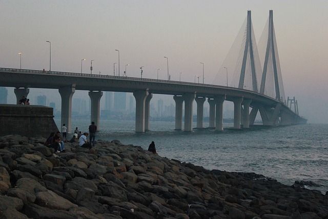
Bandra Worli Sea Link –
The Bandra-Worli Sea Link is a prominent cable-stayed Bridge Located in Mumbai, India. It connects the Western suburbs of Bandra to the Southern part of Worli, spanning the Arabian Sea. Here is some information about this iconic structure:
Purpose: The Bandra-Worli Sea Link serves as a crucial transportation link in Mumbai, significantly reducing travel time between the Western and Southern parts of the city. It has eased traffic congestion and improved connectivity in the region.
Construction: The construction of this Engineering marvel began in 2000 and was completed in several phases. It officially opened to the public in June 2009.
Design: The Bridge is characterized by its stunning cable-stayed design, with towers that rise above the sea. The cables support the road deck, giving it a distinctive and visually appealing look.
Length: The Bandra-Worli Sea Link stretches for Approximately 5.6 kilometers (3.5 miles), making it one of the longest cable-stayed Bridges in India.
Benefits: The sea link has had a significant impact on Mumbai’s traffic and infrastructure. It has reduced travel time between Bandra and Worli from about 45 minutes to just 10-15 minutes during peak hours.
Toll: To use the Bandra-Worli Sea Link, vehicles are required to pay a toll. The toll charges vary based on the type of vehicle.
Iconic Landmark: The Bridge has become an iconic Landmark in Mumbai and is often featured in movies and advertisements. Its unique architectural design and picturesque views make it a popular tourist attraction as well.
Maintenance: Regular maintenance and safety checks are conducted to ensure the bridge’s integrity and the safety of commuters.
Night Illumination: The Bridge is beautifully illuminated at night, adding to its aesthetic appeal and making it a striking sight against the Mumbai skyline.
Future Developments: There have been discussions about extending the sea link further southward to improve connectivity to other parts of the City.
The Bandra-Worli Sea Link stands as a symbol of Mumbai’s modern Infrastructure and continues to be a vital transportation artery in the City.
Bogibeel Bridge –
The Bogibeel Bridge is a significant Railway and Road Bridge located in the Northeastern part of India. It spans the Brahmaputra River in the State of Assam. Here is some information about this important infrastructure:
Purpose: The Bogibeel Bridge was constructed to enhance transportation connectivity in the northeastern region of India. It serves as a crucial link for both Railways and Roadways, connecting the Dibrugarh and Dhemaji Districts of Assam.
Construction: The construction of the Bogibeel Bridge began in the early 2000s, and it was inaugurated on December 25, 2018, by the then-Prime Minister of India, Shri Narendra Modi.
Design: This Bridge is a marvel of Engineering, featuring a combination of Road and rail, and it is India’s longest rail-cum-road Bridge. It is Approximately 4.94 kilometers (3.07 miles) in length. The Bridge has two Railway lines and a two-lane road on its top deck, making it a versatile and important transportation corridor.
Benefits: The Bogibeel Bridge has brought significant benefits to the region. It has reduced travel time between Dibrugarh and Dhemaji, improving accessibility and connectivity. Before the bridge was constructed, the Brahmaputra River acted as a major barrier to transportation during the monsoon season when the River swells.
Strategic Significance: Beyond its immediate transportation benefits, the bridge also has strategic significance, as it improves accessibility to the border areas of India and strengthens India’s military presence in the Northeastern region.
Economic Impact: The Bridge has had a positive impact on the local economy by facilitating the movement of goods and people, promoting trade, and boosting tourism in the region.
Environmental Considerations: During its construction, efforts were made to minimize the environmental impact on the sensitive Ecosystem of the Brahmaputra River. This included measures to protect the river’s ecology and ensure the Bridge’s structural integrity during floods.
Maintenance: Like any major infrastructure, the Bogibeel Bridge requires regular maintenance and safety checks to ensure its continued safe operation.
The Bogibeel Bridge is a testament to India’s commitment to improving infrastructure in its northeastern region, addressing connectivity challenges, and promoting Economic Development and strategic interests in the Area.
Vikramshila Setu –
Vikramshila Setu is a prominent Bridge located in the Indian State of Bihar. It spans the Ganges River and connects the Cities of Bhagalpur and Naugachia. The Bridge is an essential transportation link in the region, facilitating the movement of people and goods between these two areas.
Vikramshila Setu is named after the ancient Vikramshila University, which was a renowned Buddhist learning center in the region during the Pala Empire in the 8th to 12th centuries. The Bridge serves as a symbol of both modern Infrastructure Development and the Historical significance of the Area.
Construction of the Vikramshila Setu was a significant Engineering achievement and has played a crucial role in improving connectivity in the region, benefiting the local economy and residents. It has become an important Landmark and a vital transportation route in Bihar, contributing to the overall Development of the State.
Vembanad Rail Bridge –
The Vembanad Rail Bridge is a significant Railway Bridge located in the Southern State of Kerala, India. This Bridge spans across the Vembanad Lake, which is one of the Largest and most picturesque backwaters in the region. The bridge is an important part of the Indian Railways network, connecting the cities of Alappuzha (Alleppey) and Kochi (Cochin).
Here are some key features and information about the Vembanad Rail Bridge:
Location: The Vembanad Rail Bridge is situated in the Alappuzha District of Kerala. It specifically connects the towns of Edappally and Vallarpadam, which are part of the greater Kochi metropolitan Area.
Importance: The Bridge plays a crucial role in facilitating rail transportation between the Alappuzha and Kochi regions, providing a vital link for both passenger and freight Trains.
Length: The Bridge is Approximately 4.62 kilometers (about 2.87 miles) in length, making it one of the Longest Rail Bridges in India.
Scenic Beauty: The Vembanad Lake is known for its natural beauty and serene surroundings, and the rail journey across this Bridge offers passengers stunning views of the lake and the lush green landscapes that Kerala is famous for.
Vallarpadam Container Terminal: The Rail Bridge serves as a crucial connection to the Vallarpadam International Container Transshipment Terminal (ICTT), which is one of the major container terminals in India. This terminal plays a vital role in International trade and Commerce.
Engineering Marvel: The construction of the Vembanad Rail Bridge was a remarkable engineering feat due to the challenging terrain and the need to traverse the backwaters. It required innovative engineering solutions to ensure its stability and longevity.
Accessibility: The Bridge is part of the Indian Railways’ Southern Railway Zone, and it is well-connected to the broader Railway Network in the region.
Tourist Attraction: In addition to its practical importance, the Vembanad Rail Bridge has also become a tourist attraction, with travelers often appreciating the scenic beauty and unique experience of crossing the Bridge.
Overall, the Vembanad Rail Bridge is a vital transportation link in Kerala, serving both economic and touristic purposes, while also showcasing the natural beauty of the region.
Digha Sonpur Bridge –
The Digha-Sonpur Bridge, also known as the Digha-Allahabad Bridge, is a significant infrastructure project in India. This Bridge spans the Ganges River and connects the towns of Digha in Patna, Bihar, and Sonpur in Saran, Bihar. Here is some information about the Digha-Sonpur Bridge:
Location: The Digha-Sonpur Bridge is located in the northern part of India, specifically in the state of Bihar. It crosses the Ganges River, one of the major rivers in India.
Purpose: The primary purpose of the Digha-Sonpur Bridge is to enhance connectivity and transportation between the towns of Digha and Sonpur. It plays a vital role in improving road and rail connectivity in the region.
Types of Connectivity: This Bridge serves as both a road and Rail Bridge. It accommodates both vehicular Traffic and Railway Tracks, making it a multi-modal transport link.
Length and Design: The Digha-Sonpur Bridge is quite long, spanning several kilometers across the river. It is a significant engineering feat, designed to withstand heavy traffic loads and river conditions.
Importance: The Bridge has great importance in terms of improving transportation and connectivity in Bihar. It facilitates the movement of goods, people, and vehicles between the two towns and the surrounding regions.
Development: The construction of the Digha-Sonpur Bridge was part of a broader infrastructure development initiative aimed at improving transportation Networks in Bihar and enhancing economic activity in the region.
Impact: The Bridge has had a positive impact on the local economy, as it has eased the movement of agricultural produce, industrial goods, and people. It has also reduced travel time and congestion on alternative routes.
Railway Connectivity: The inclusion of Railway Tracks on the Bridge allows for the efficient movement of trains, enhancing the connectivity of the Railway Network in the Area.
Tourism: The Bridge has also attracted tourists due to its impressive Engineering and the scenic views it offers of the Ganges River.
In summary, the Digha-Sonpur Bridge is a crucial infrastructure project in Bihar, India, providing essential road and rail connectivity across the Ganges River, facilitating Economic Development and improving transportation in the region.
Arrah Chhapra Bridge –
The Arrah Chhapra Bridge is a significant infrastructure project located in the Indian state of Bihar. This Bridge plays a crucial role in connecting the towns of Arrah and Chhapra, both of which are situated along the banks of the Ganges River.
The construction of this Bridge was aimed at improving transportation and connectivity in the region. Before its completion, people had to rely on ferries to cross the river, which could be time-consuming and unreliable, especially during monsoon seasons when the River swells.
The Arrah Chhapra Bridge provides a more efficient and dependable means of crossing the Ganges River, thereby facilitating the movement of goods and people between these two towns and the surrounding areas. Improved connectivity can have a positive impact on the local Economy and quality of life for residents.
Infrastructure projects like the Arrah Chhapra Bridge are essential for the Development of regions, as they promote economic growth, ease transportation bottlenecks, and enhance accessibility for communities on both sides of the River.
Godavari Bridge –
The Godavari Bridge is a significant Bridge located in India, specifically spanning the Godavari River. There are multiple Bridges over the Godavari River, so it’s essential to specify which one you are referring to.
Godavari Arch Bridge, Rajahmundry: This is one of the most famous Bridges over the Godavari River. It’s also known as the Kovvur-Rajahmundry Bridge. This Bridge is an arch Bridge and connects the towns of Kovvur and Rajahmundry in the Indian state of Andhra Pradesh. It’s an iconic structure and a vital transportation link in the region.
Old Godavari Bridge, Rajahmundry: Also known as the Havelock Bridge, it is a decommissioned Railway Bridge located next to the Godavari Arch Bridge in Rajahmundry. It is a Historic structure with a unique design.
Godavari Bridge, Bhadrachalam: This Bridge connects the town of Bhadrachalam in Telangana with Chinturu in Andhra Pradesh. It plays a crucial role in connecting these regions and facilitating transportation.